Published on Thursday, 7 November 2019 at 11:29:00 AM
Name changes:
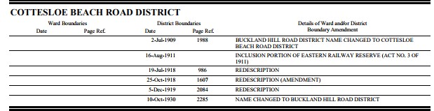
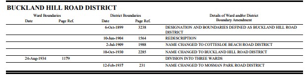
Buckland Hill Road District 6th October 1899 – 2nd July 1909
Cottesloe Beach Road District 2nd July 1909 – 10th October 1930
Buckland Hill Road District 10th October 1930 – 12th Feb 1937
Mosman Park Road District 12th Feb 1937 – 23rd June 1961
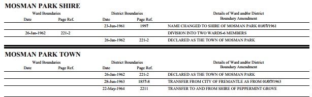
Shire of Mosman Park 23rd June 1961 – 26th January 1962
Town of Mosman Park 26th January 1962 onwards.
MUNICIPAL CHANGES
ROAD DISTRICT 12-Feb-1937 to 23-Jun-1961
SHIRE 23-Jun-1961 to 26-Jan-1962
TOWN 1962 to Current
(WA Electoral Commission, Municipality Boundary Amendments Register (release 2.0), 31st May 2003.)
Declared a Town and split into north and south Wards on 26th January 1962
(Government Gazette 26/1/1962, pg.1)
MUNICIPAL BOUNDARY ADJUSTMENTS
(WA Electoral Commission, Municipality Boundary Amendments Register (release 3.0), 31st July 2007.)
Entry for 28th June 1963
Transfer of Territory from the City of Fremantle to the Town of Mosman Park. All that portion of land bounded by lines starting from the intersection of the right bank of the Swan River and the prolongation south-easterly of the south-western boundary of North Fremantle Lot 211, a point on the present boundary of the City of Fremantle and extending north-westerly to and along the south-western boundary of Lot 211 aforesaid to its western corner; thence northeasterly along the north-western boundary of that lot to the south-eastern corner of Class “B” Reserve 2976; thence north-westerly along the northeastern boundary of that reserve to the southeastern side of McCabe Street; thence south-westerly along that side to a point situate in prolongation south-easterly of the north-eastern boundary of lot 332; thence north-westerly to and along that boundary to the north-eastern corner of that lot; thence generally westerly along northern boundaries of that lot and lots 327, 326 and lot 2 of North Fremantle Lot 174, as shown on Land Titles Office Diagram 26695, to the northwestern corner of lot 2 aforesaid; thence south-westerly to the north-eastern corner of lot 333 (Reserve 25752); thence westerly along the northern boundary of that lot, lot 292 and again lot 333 and onwards to the shore of the Indian Ocean, a point on the present boundary of the City of Fremantle aforesaid and thence generally northerly, easterly, southerly and generally westerly along that present boundary to the starting point. The area transferred to form portion of the South Ward thereof.
Area of land involved, 236 acres. (955058m2)
(Public Plan North Fremantle Townsite.) LAND AGENTS
Entry for 22nd May 1964
WHEREAS it is provided in paragraph (f ) of subsection (2) of the Local Government Act, 1960, that upon effective presentation of a petition under the Common Seal of the Council or Councils affected, the Governor may alter and adjust the boundaries of adjoining districts; and whereas the municipalities of the Town of Mosman Park and Shire of Peppermint Grove respectively have presented a petition to the Governor praying that the
joint boundary between the two districts should be slightly altered and adjusted; and whereas it is considered expedient that the prayer of the petitioners should be granted: Now, therefore, His Excellency the Governor, acting by and with the advice and consent of the Executive Council, doth hereby alter and adjust the boundaries of the municipalities of the Town of Mosman Park and Shire of Peppermint Grove respectively by
(a) transferring from the Town of Mosman Park to the Shire of Peppermint Grove the land designated for such transfer in the schedule hereto; and
(b) transferring from the district of the municipality of the Shire of Peppermint Grove to the district of the municipality of the Town of Mosman Park the land designated for such transfer in the schedule hereto.
(Sgd.) R. H. DOIG,
Clerk of the Council.
Schedule
Transfer of Territory from the district of the Town of Mosman Park to the district of the Shire of Peppermint Grove. All that portion of land bounded by lines starting from the north-eastern corner of lot 19 of Mosman Park Sub Lot 119, as shown on Land Titles Office Diagram 29040, a point on the present boundary of the Shire of Peppermint Grove, and extending westerly along the northern boundary of that lot to the eastern boundary of lot 17, as shown on Land Titles Office Diagram 18634; thence northerly along that boundary to the south-eastern corner of lot 1 as shown on Land Titles Office Diagram 1106, a point on the boundary of the Shire of Peppermint Grove aforesaid, and thence easterly and southerly along that boundary to the starting point. Area of land involved, 2.4 perches.
Transfer of Territory from the district of the Shire of Peppermint Grove to the district of the Town of Mosman Park. All that portion of Mosman Park Sub Lot 119 which is included in lot 21 on Land Titles Office Diagram 24206. Area of land involved, 1 rood 4,3 perches.
Entry for 9th April 1976
All that portion of land bounded by lines commencing at the northwestern corner of North Fremantle Town Lot 338, a point on the present boundary of the City of Fremantle, and extending northeasterly and southeasterly along boundaries of that lot and onward to the southeastern side of McCabe Street, a point on the present boundary of the City of Fremantle and thence southwesterly and northwesterly along boundaries of that City to the starting point . Area of land involved, 3329m2 . (0.8226138 acres)
(Lands and Surveys Public Plan F25-4 .)
Back to All News